South Hebron Hills
Wadi Jheish
Resident
Number of Families
15
Names of Families
Nawaja'ah
Farmers Origin/Family
Yatta
Refugees
not refugee
Spatial/Building
Land Ownership
private
Land Ownership - details
The community owns its own lands
Planning
submitted plan
Planning - details
A plan was prepared and submitted but was not approved.
Structure Type
- tent
- tin shack
Building materials - details
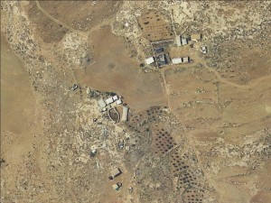
The community lives in tents and tin shacks. They have one large cave used mainly for animal use
Infrastructure/Services
Access to Community
- pedestrian
- private vehicle
- 4X4 vehicle
Access to Community - details
No roads connect the community to the main road (number 317). They mostly walk to the main road to reach the bus, or use donkeys.
Water Access
- water tank
- cistern\well
Water Access - details
The filling points for the water tanks are in A0Tuwani or Imneizel
Electric Connection
Electric Connection - details
Solar panels provided by Comet-ME in 2017.
Health Care
- mobile clinic in community
- clinic in neighboring community
- clinic in distant town/village
Health Care - details
The community rarely receive health care in their area due to difficulties in access. A mobile clinic comes to Susya, and the nearest clinics and hospital are in Yatta.
Location of Services
Imneizel and Yatta
Education
Kindergarten
No
Location of School #1
Imneizel
general description [school #1]
- Boys
- Girls
- Primary school
Distances to schools [school #1]
2001 - 5000 meters
Location of School #2
Imneizel
Time to schools [school #1]
16 - 30 minutes
general description [school #2]
- Boys
- Girls
- Middle school
Time to schools [school #2]
16 - 30 minutes
Distances to schools [school #2]
2001 - 5000 meters
Location of School #3
Yatta
general description [school #3]
- Boys
- Girls
- High School
Distances to schools [school #3]
more than 5001 meters
Time to schools [school #3]
31 minutes - 1 hour
Schools - details
The elementary school is in Imneizel from first to eighth grades. All high schools are in Yatta.
Travel to school [school #1]
- bus
- easy walk
- donkey
Travel to school [school #2]
- bus
- easy walk
- donkey
Travel to school [school #3]
- bus
- easy walk
Accessibility to school [school #1]
4
Accessibility to school [school #2]
4
Accessibility to school [school #3]
6
History
History
The community is originally from Yatta, they sit on their private lands.
livelihood
Seasonal Movement
no
Community Initiatives
public building
Initiative in the community - details
The community is trying to pave an access road to connect itself to the main road (number 317). The road has been destroyed several times by the IDF.
Other Occupation
- shepherding
- daily laborer
- agriculture
Main Occupation
- shepherding
- temporary employment in Israel
Woman's Occupation
- taking care of the herd
- taking care of the kids
- housekeeping
- agriculture
Threats and obstacles
Threats and Obstacles
fjfxjsfjsyjsyj
- nature reserve
- close to settlement
- settler violence
- road
Threats and Obstacles - details
Access roads are closed by the IDF, making getting in and out of the community difficult. The community also suffers from frictions with nearby settlements. According to the community settlers hit an old woman in 2018.
Number of Demolition Orders
15
Number of Demolitions
5
Demolitions - date of update
September 17, 2010
Demolitions - details
According to residents the last demolition took place in 2017, when a structure made of concrete and metal which was supposed to serve as a guest house and a meeting point was demolished.


