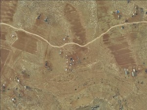
East of Deir Dubwwan village and road 458
Wadi al Seeq
Resident
Number of Families
35
Tribe
testing the tooltip
Ka’abneh;Jahalin
Sub-Tribe
Zweidin, Saraya'a, Mlehat
Names of Families
Zweidin and A'raa'ra (Jahalin), Dar Abu Eid (Yatta), Badran from Deir Dubwan.
Farmers Origin/Family
2 families from Yatta, 1 family from Deir Dubwan
Refugees
official refugee status;non-official refugee status
Refugees Details
The refugees hold UNRWA cards
Spatial/Building
Land Ownership
private;lease;state owned land
Planning
No plan
Structure Type
tent;tin shack
Infrastructure/Services
Access to Community
private vehicle;4X4 vehicle;public transit
Water Access
water tank;cistern\well
Water Access - details
The community fills their water tanks from a house next to the Caramelo checkpoint. The house that is connected to water due to an old permit. The owner of the house is from the same family as one of the families in the community (Zweidin). They buy 3 cubes of water for 25 NIS. Most of the wells (nearly 12) have been confiscated by settlers.
Electric Connection
Electric Connection - details
Comet-ME is working with the community on the establishment of solar panel, which is expected to operate by January of 2020.
Health Care
mobile clinic in community;clinic in distant town/village
Health Care - details
The UNRWA clinic used to visit the community but these visits stopped in 2018.
The closest health clinic is in At Tayba village or Deir Jarir. The nearest hospitals are in Ramallah and Jericho.
The closest health clinic is in At Tayba village or Deir Jarir. The nearest hospitals are in Ramallah and Jericho.
Location of Services
Villages of Deir Dubwan, Deir Jrir and Taybeh
Education
Location of School #1
Wadi al Seeq
general description [school #1]
Boys;Girls;Primary school
Distances to schools [school #1]
0-300 meter
Location of School #2
Deir Jrir
Time to schools [school #1]
5 - 15 minutes
general description [school #2]
Boys;Girls;Middle school
Time to schools [school #2]
over 1 hour
Distances to schools [school #2]
more than 5001 meters
Location of School #3
Deir Jrir
general description [school #3]
Boys;Girls;High School
Distances to schools [school #3]
more than 5001 meters
Time to schools [school #3]
over 1 hour
Schools - details
The primary school is attended by the children of this and the surrounding communities. Transportation to school is provided by the ministry of education yet it is unreliable and the community reports that the bus does not always arrive and many times arrives late.
Travel to school [school #1]
easy walk
Travel to school [school #2]
bus;difficult walk;private car
Travel to school [school #3]
bus;difficult walk;private car
Accessibility to school [school #1]
2
Accessibility to school [school #2]
6
Accessibility to school [school #3]
6
Accessibility to school - STAFF [school #1]
4
Accessibility to school - STAFF [school #2]
2
Accessibility to school - STAFF [school #3]
2
History
History
The Kaa'bneh were expelled from their lands in 1948. Between 1948 to 1995 they were displaced by the Israeli authorities severel times from the areas in which they settled, originally in South Hebron Hills and then around Jericho. In 1995 they reached an agreement with the IDF to move to Wadi al Seeq, where they reside today. They are unable to move anywhere else since.
The Jahalin families joined the community in 2003 due to a conflicts with other families. The families from Yatta joined the community a bit later.
With the growing number of families, the available herding land has significantly diminished, leading to a host of issues and challenges.
The Jahalin families joined the community in 2003 due to a conflicts with other families. The families from Yatta joined the community a bit later.
With the growing number of families, the available herding land has significantly diminished, leading to a host of issues and challenges.
livelihood
Seasonal Movement
no
Seasonal Movement - details
The community has stayed permanently in this area since 1995.
Community Initiatives
water;public building
Initiative in the community - details
primary school
Other Occupation
shepherding;temporary employment in settlement;agriculture
Main Occupation
shepherding;agriculture
Woman's Occupation
taking care of the herd;taking care of the kids;housekeeping
General Livelihood - details
98% of the families depend on shepherding. Some work in agriculture for a temporary period and only one person from Kaa'bneh is employed as a teacher in Mu'arrajat East school.
Threats and obstacles
Threats and Obstacles
fjfxjsfjsyjsyj
firing zone/closed military zone;nature reserve;settler violence;road;Dump site
Threats and Obstacles - details
The movement of the community is severely restricted from all sides. In the south is a nature reserve, in the north agricultural private lands, in the east a closed military zone and Road 458 is to the west of the community. This makes it difficult to access the community and to graze their herds.
Abu Bashar brought up the waste disposal site planned for the northeast side of the community, expressing his hope that it would serve as a deterrent for settlers in the area. He emphasized that the Bedouins are prepared to bear the environmental consequences of such a site but are unwilling to endure the harm caused by the presence of settlers.
Recently when settlers arrived, his threats led three families to leave the village.
Number of Demolition Orders
60
Number of Demolitions
5


