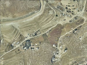
Jerusalem periphery, adjacent and east of Al Eizariya
Wadi al-Jimel
Resident
Number of Families
15
Tribe
testing the tooltip
Jahalin
Sub-Tribe
Salamat
Names of Families
Sayaleh
Refugees
- official refugee status
- non-official refugee status
Spatial/Building
Land Ownership
- private
- lease
Land Ownership - details
Most of the land is leased from inhabitants of Al-Eizariya. One piece of land was purchased by the community, and it is used as an olive grove.
Planning
No plan
Planning - details
The community is part of the aster plan for Al-Eizariya , promoted by MoLG (PLO) and in the process of being submitted to the ICA.
Structure Type
- tent
- tin shack
- wood
Infrastructure/Services
Access to Community
- private vehicle
- 4X4 vehicle
Access to Community - details
The road surrounding the village (which follows the route of the separation barrier) is for IDF use only. The community sometimes uses it, though fines for those who do are of 2000 NIS. A small side road the goes down the Wadi serves as the main access road. The IDF sometimes blocks this road with concrete blocks.
A second access road is an ancient Ottoman road going down from Al-Eizariya from the eastern side, but it is very disturbed. In days of heavy rain, all access roads are blocked.
A second access road is an ancient Ottoman road going down from Al-Eizariya from the eastern side, but it is very disturbed. In days of heavy rain, all access roads are blocked.
Water Access
- connection to neighboring village
- cistern\well
Water Access - details
The community is connected to the water system of Al- Eizariya. The connection is weak and so they also buy water tanks when needed. They used to own three wells, but today they have just one as the access to the other two was lost with the building of the separation barrier.
The natural circumstances allow for agriculture since water run through the area in the winter.
The natural circumstances allow for agriculture since water run through the area in the winter.
Electric Connection - details
There are some solar panels in the community, and an independent connection to Al- Eizariya.
Health Care
clinic in neighboring village
Health Care - details
The nearest health center is in Al-Eizariya.
Location of Services
Al-Eizariya
Education
Kindergarten
No
Location of School #1
Al-Eizariya
general description [school #1]
- Boys
- Girls
- Primary school
Distances to schools [school #1]
2001 - 5000 meters
Location of School #2
Al-Jabal
Time to schools [school #1]
over 1 hour
general description [school #2]
- Boys
- Girls
- Primary school
- Middle school
Time to schools [school #2]
over 1 hour
Distances to schools [school #2]
1001 - 2000 meters
Location of School #3
Al-Eizariya
general description [school #3]
- Girls
- Middle school
- High School
Distances to schools [school #3]
2001 - 5000 meters
Location of School #4
Al-Eizariya
Time to schools [school #3]
over 1 hour
general description [school #4]
- Boys
- Middle school
- High School
Distances to schools [school #4]
2001 - 5000 meters
Time to schools [school #4]
over 1 hour
Schools - details
For the most part the children walk to the main road and take public transportation to their schools from there. It takes more than an hour to reach the schools by foot.
In the winter it becomes impossible to walk out of the community as the roads are flooded, and children cannot reach their schools.
In the winter it becomes impossible to walk out of the community as the roads are flooded, and children cannot reach their schools.
Travel to school [school #1]
- bus
- difficult walk
- private car
Travel to school [school #2]
- difficult walk
- private car
Travel to school [school #3]
- bus
- difficult walk
- private car
Travel to school [school #4]
- bus
- difficult walk
- private car
Accessibility to school [school #1]
7
Accessibility to school [school #2]
6
Accessibility to school [school #3]
7
Accessibility to school [school #4]
7
History
History
The community was expelled from the Negev in 1948. They settled first near Bethlehem and arrived to their current location in the 60's, in search of grazing lands and water sources.
livelihood
Seasonal Movement
no
Community Initiatives
agriculture
Initiative in the community - details
At least one piece of land which is privately owned is cultivated with olives. They also grow other vegetables on their lands.
Other Occupation
- shepherding
- permanent employment in Palestinian town
- unemployed
- agriculture
Main Occupation
- shepherding
- permanent employment in Palestinian town
- unemployed
Woman's Occupation
- taking care of the herd
- taking care of the kids
- housekeeping
General Livelihood - details
Men from the community work mostly in factories in Ma'ale Adumim and Al- Eizariya.
The community own about 700 sheep plus several camels. They used to own more but grazing areas were diminished, leading to a decrease in live stock.
The community own about 700 sheep plus several camels. They used to own more but grazing areas were diminished, leading to a decrease in live stock.
Threats and obstacles
Threats and Obstacles
fjfxjsfjsyjsyj
- firing zone/closed military zone
- settler violence
- separation barrier
- road
Threats and Obstacles - details
After the separation barrier will be completed the will remain completely disconnected from the nature surrounding them which is essential for grazing. Additionally, a road is planned to cut through the Wadi and the areas surrounding it will become a buffer zones.
The rain flooding in the channel nearby helps them grow agriculture, but when its heavy rain the channel floods and causes damage.
The rain flooding in the channel nearby helps them grow agriculture, but when its heavy rain the channel floods and causes damage.
Number of Demolition Orders
14
Number of Demolitions
1
Demolitions - date of update
September 17, 2010
Demolitions - details
According to the community a house and an olive orchard were demolished


