North of Jericho, south of Road 449
Mu'arrajat East
Resident
Tribe
testing the tooltip
Ka’abneh
Sub-Tribe
Ka’abneh - Furijat
Names of Families
Mleihat
Refugees
- official refugee status
- non-official refugee status
Spatial/Building
Land Ownership
state owned land
Planning
Demarcation plan
Planning - details
There was an agreement with the authorities back in the 80's for a certain area of registered state land that was given to the community
Structure Type
- tent
- tin shack
- EU shack
- concrete
Infrastructure/Services
Access to Community
- pedestrian
- private vehicle
- public transit
Water Access
authorized connection
Water Access - details
They have a filling point next to the community school
Health Care
clinic in distant town/village
Health Care - details
in Jericho
Location of Services
Jericho
Education
Kindergarten
yes
Kindergarten - details
In Mu'arrajat East attached to the school
Location of School #1
Imleihat
general description [school #1]
- Boys
- Girls
- Primary school
Distances to schools [school #1]
0-300 meter
Location of School #2
JeImleihat
Time to schools [school #1]
5 - 15 minutes
general description [school #2]
- Boys
- Girls
- Middle school
Time to schools [school #2]
5 - 15 minutes
Distances to schools [school #2]
0-300 meter
Location of School #3
Imleihat
Distances to schools [school #3]
0-300 meter
Time to schools [school #3]
5 - 15 minutes
Travel to school [school #1]
- easy walk
- difficult walk
Travel to school [school #2]
- easy walk
- difficult walk
Travel to school [school #3]
- easy walk
- difficult walk
Accessibility to school [school #1]
2
Accessibility to school [school #2]
2
Accessibility to school [school #3]
2
Accessibility to school - STAFF [school #1]
3
Accessibility to school - STAFF [school #2]
3
History
History
In 1948 they were expelled to South Hebron Hills and a few years later they moved to Deir Dubwan lands in an area called Al Jutheh, near Ramallah. In 1983 the IDF declared Al Jutheh as a military zone so they moved to their current location in Mua'arajat east.
livelihood
Seasonal Movement
no
Community Initiatives
public building
Initiative in the community - details
Building mosque
Other Occupation
shepherding
Main Occupation
shepherding
Woman's Occupation
- taking care of the herd
- taking care of the kids
- housekeeping
Threats and obstacles
Threats and Obstacles
fjfxjsfjsyjsyj
- firing zone/closed military zone
- nature reserve
- close to settlement
- road
Number of Demolition Orders
34
Number of Demolitions
8
Demolitions - details
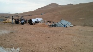
According to residents, 20 structures were demolished by the army the rest were demolished by people in consequence of demolition orders


