Jerusalem periphery, south of Road 1 leading to Jericho
Khan al Ahmar Al-Kurshan
Basic info+
Resident+
Number of Families
12
Tribe
testing the tooltip
Jahalin
Sub-Tribe
Abu Dahouk
Names of Families
Kurshan
Refugees
- non-official refugee status
- official refugee status
Refugees Details
Expelled from Tel Arad in 1948
Spatial/Building+
Land Ownership
- expropriation
- lease
- private
Land Ownership - details
The land, previously privately owned by residents of Isawiya, has been expropriated as part of the expropriation in 1975, for the benefit of Ma’ale Adumim.
Planning
community initiative plan
Planning - details
A guideline planning (Planning principals) for the communities in Al Khan Al Ahmar area, was submitted to the ICA but rejected.
Structure Type
- tent
- tin shack
Building materials - details
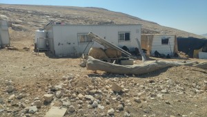
Wood, tin and cloth
Infrastructure/Services+
Access to Community
- 4X4 vehicle
- pedestrian
Access to Community - details
The channel next to the road gets flooded by rain water in the winter, preventing access to and from the community .
Water Access
authorized connection
Water Access - details
They have an authorized connection by a meter through the Israeli Mekorot Company, but the pipes are exposed to open air an so get broken due to weather conditions, and lack of maintenance.
Electric Connection
Electric Connection - details
Solar panels has provided by ACF in 2015, but they are partly broken or are in need of maintenance. Comet-ME are promoting a project which will provide solar panels to the community.
Health Care
- clinic in distant town/village
- clinic in neighboring community
Health Care - details
The Al-Islah infirmary reaches the Abu Fallah community nearby once a month for basic services only.
The nearest clinics and hospitals are in Jericho and Ramallah.
The nearest clinics and hospitals are in Jericho and Ramallah.
Location of Services
Jericho and Ramallah
Education+
Kindergarten
No
Location of School #1
Abu Helw
general description [school #1]
- Boys
- Girls
- Primary school
Distances to schools [school #1]
1001 - 2000 meters
Location of School #2
Jericho
Time to schools [school #1]
16 - 30 minutes
general description [school #2]
- Girls
- High School
- Middle school
Time to schools [school #2]
31 minutes - 1 hour
Distances to schools [school #2]
more than 5001 meters
Location of School #3
Jericho
Distances to schools [school #3]
more than 5001 meters
Time to schools [school #3]
31 minutes - 1 hour
Schools - details
The access road to Abu Helw can be dangerous and blocked due to flooding of rain water. In difficult weather they don't send their children to school. Nowadays they don't have children in high schools. Transportation can be difficult as well, since vehicles are forbidden from stopping on the main road.
Travel to school [school #1]
- difficult walk
- donkey
Travel to school [school #2]
bus
Travel to school [school #3]
bus
Accessibility to school [school #1]
5
Accessibility to school [school #2]
4
Accessibility to school [school #3]
4
History+
History
After their expulsion from Tel Arad, the community arrived to the area, as they were attracted by the availability of suitable grazing land. They reached an agreement with the private land owners from Isawiya. The commnunity has used the areas as seasonal grazing lands in the winter, even before they settling there permanently.
Following the reduction in grazing lands, options for mobility, and pressure placed on residents, people had to eventually settle down in their current locality.
Following the reduction in grazing lands, options for mobility, and pressure placed on residents, people had to eventually settle down in their current locality.
livelihood+
Seasonal Movement
partly
Seasonal Movement - details
Only part of some families move in the summer to Beit Iksa, and in the winter to Tabiq Qteiff
Community Initiatives
no Initiatives
Other Occupation
- daily laborer
- shepherding
- unemployed
Main Occupation
- daily laborer
- shepherding
- unemployed
Woman's Occupation
- housekeeping
- taking care of the herd
- taking care of the kids
General Livelihood - details
The community relies on their herds for their livelihood. Only one person works in Mishor Adomim industrial Area.
Threats and obstacles+
Threats and Obstacles
fjfxjsfjsyjsyj
- firing zone/closed military zone
- within settlement municipal boundary
- within settlement plan
Threats and Obstacles - details
Limitation of access to grazing land and water resources.
Close to Mishor Adumim industrial zone, which restricts the movement of the community.
The distance from the main road decreases access to services, making it difficult for mothers, children, and seniors to leave the community. One family with children who needed daily medical care had to move to Aqbet Jabr to be close to services due to difficult access on daily basis to and from the locality.
Number of Demolition Orders
8
Number of Demolitions
8
Demolitions - details
Dwelling structures demolished on August 2016


