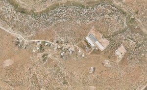
South Hebron Hills, east of Road 356
Khallet Hajar Tahta
Resident
Number of Families
2
Tribe
testing the tooltip
A'zazmeh;Selmi
Refugees
Unknown
Spatial/Building
Land Ownership
Unknown
Planning
No plan
Structure Type
tin shack;concrete
Infrastructure/Services
Access to Community
private vehicle;4X4 vehicle
Water Access
connection to neighboring village
Water Access - details
Connection to neighboring town, Khallet al Maiyya.
Electric Connection
Electric Connection - details
Connection to neighboring town, Khallet al Maiyya.
Health Care
clinic in neighboring community
Health Care - details
From Al Bouieb health centre and Yatta or Hebron hospitals.
Education
Location of School #1
Al Buweib
general description [school #1]
Boys;Girls;Primary school
Location of School #2
Zif
general description [school #2]
Middle school
Location of School #3
Yatta
general description [school #3]
High School
livelihood
Seasonal Movement
no
Community Initiatives
Unknown
Other Occupation
shepherding
Main Occupation
shepherding
Woman's Occupation
unknown
Threats and obstacles
Threats and Obstacles
fjfxjsfjsyjsyj
settler violence
Threats and Obstacles - details
Settlers attack the community and frighten the children.
Number of Demolition Orders
11


