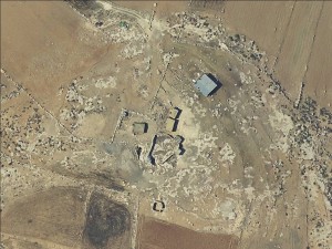
South Hebron Hills, 3 kilometers west of Green Line
Iqtait
Resident
Refugees
not refugee
Spatial/Building
Planning
No plan
Structure Type
- tent
- tin shack
- stone
Infrastructure/Services
Access to Community - details
A long dirt road leads to the community
Water Access
- water tank
- cistern\well
Electric Connection
Health Care
- clinic in neighboring community
- clinic in distant town/village
Health Care - details
The community uses the clinics in Dahariya and Hebron
Education
Location of School #1
Annab
general description [school #1]
- Boys
- Girls
- Primary school
Location of School #2
Ramadin
general description [school #2]
- Boys
- Girls
- Middle school
- High School
Travel to school [school #1]
donkey
Travel to school [school #2]
donkey
Accessibility to school [school #1]
6
Accessibility to school [school #2]
6
livelihood
Seasonal Movement
yes
Seasonal Movement - details
The community only resides in the area during the summer months
Other Occupation
shepherding
Main Occupation
shepherding
Threats and obstacles
Threats and Obstacles
fjfxjsfjsyjsyj
archeology
Number of Demolition Orders
1
Number of Demolitions
0
Demolitions - date of update
September 17, 2010
Demolitions - details
The community received some notices to evacuate the area


