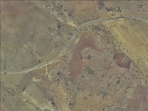
Northern West Bank, along Road 5799
Hammamat al Maleh
Resident
Number of Families
6
Refugees
not enough data
Spatial/Building
Land Ownership
- private
- lease
Land Ownership - details
Lands are owned by inhabitant of Tubas
Planning
No plan
Structure Type
Unknown
Infrastructure/Services
Water Access
water tank
Water Access - details
Buy water from Tayasir
Electric Connection
Health Care
- clinic in neighboring community
- clinic in distant town/village
Health Care - details
The nearest hospital is in Tubas
Location of Services
Tubas
Education
Kindergarten
Unknown
Location of School #1
Tayasir
general description [school #1]
- Boys
- Girls
- Primary school
- Middle school
- High School
Distances to schools [school #1]
more than 5001 meters
Schools - details
School bus provided by the PA
Travel to school [school #1]
bus
Accessibility to school [school #1]
6
livelihood
Seasonal Movement
yes
Seasonal Movement - details
The shepherds move to Tubas in June and return in the beginning of the school year
Community Initiatives
Unknown
Other Occupation
shepherding
Main Occupation
shepherding
General Livelihood - details
The community owns about 5000 sheep/goats. Their products are marketed in Tubas.
Threats and obstacles
Threats and Obstacles
fjfxjsfjsyjsyj
- firing zone/closed military zone
- close to settlement
- settler violence
Threats and Obstacles - details
Settlements nearby and the closed military zone severely restrict grazing areas. The military zones are also dangerous as their are remnants of mines and artillery, which killed a young man from the community.
Number of Demolition Orders
17
Number of Demolitions
12
Demolitions - date of update
September 17, 2010


