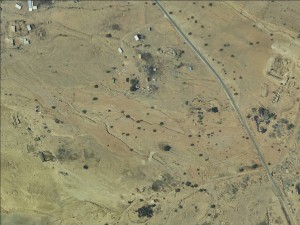
Jordan Valley, north of Jericho
Fasayil al Wusta
Resident
Tribe
testing the tooltip
Rashaydeh
Sub-Tribe
Abu Kharabish
Names of Families
Abu Kharabish, Qreinat
Refugees
official refugee status
Spatial/Building
Land Ownership
state owned land
Planning
No plan
Planning - details
The ICA prepared two detailed plans, one for Fasayil Tahta and one for Fasayil al Fouqa but none of them included the area of Fasayil al Wusta. The authorities want the residents of Fasayil al Aasta to move to the planned area. However, none of these plans received an advanced statutory phase.
Structure Type
tent
Infrastructure/Services
Access to Community
- pedestrian
- private vehicle
Water Access
water tank
Electric Connection
Health Care
- clinic in neighboring community
- clinic in distant town/village
Health Care - details
The nearest clinic is in Fasayil Tahta. The main hospital is in Jericho
Location of Services
Fasayil Tahta
Education
Kindergarten
No
Location of School #1
Fasayil Tahta
general description [school #1]
- Boys
- Girls
- Primary school
- Middle school
- High School
Distances to schools [school #1]
301 - 1000 meter
Time to schools [school #1]
5 - 15 minutes
Travel to school [school #1]
- difficult walk
- private car
Accessibility to school [school #1]
3
History
History
From Ein Gedi area
livelihood
Seasonal Movement
no
Community Initiatives
no Initiatives
Other Occupation
shepherding
Main Occupation
shepherding
Woman's Occupation
- taking care of the herd
- taking care of the kids
- housekeeping
Threats and obstacles
Threats and Obstacles
fjfxjsfjsyjsyj
- close to settlement
- within settlement municipal boundary
Threats and Obstacles - details
The community sits within a declared archaeological site
Number of Demolition Orders
38
Number of Demolitions
24
Demolitions - details
According to residents, 96 demolition orders were issued for both Fasayil al Foqa and Fasayil al Wusta


