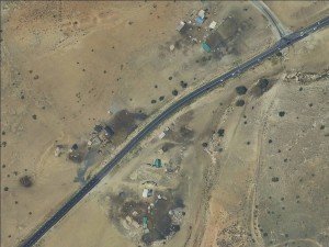
Northern Jordan Valley, along Road 578
Ein al Hilwa
Resident
Number of Families
8
Names of Families
Daraghmeh - Dar Abu Mohsen (sub family)
Farmers Origin/Family
Tubas
Refugees
not refugee
Spatial/Building
Land Ownership
- private
- lease
- church
Land Ownership - details
The lands are owned by the church of the Latin Patriarchy
Planning
No plan
Planning - details
the lawyer of the communities in defending the requisition orders in the area and they have submitted a plan.
Structure Type
- tent
- tin shack
- wood
Infrastructure/Services
Access to Community
- pedestrian
- public transit
Access to Community - details
The community uses public transportation which runs from Tubas through Tayasir.
Water Access
- water tank
- spring
Water Access - details
The spring of Ein al Hilweh was used for both human and animal drinking but since 2010 it is only used for animal. In the past they used to fill their well with the spring water and pump the water through pipes but the Israeli authorities forbade the community from rehabilitating the spring. Today they buy water tanks from Ein al Beida
Electric Connection - details
The community has solar panels but they do not function well and most of them rely on generators.
Health Care
- mobile clinic in community
- clinic in distant town/village
Health Care - details
A mobile clinic visits the area two days a week through the health administrative of Tubas. The nearest hospital is the Turkish hospital in Tubas. In 2019 the PA have insured most of the Pastoral communities in Tubas.
Location of Services
Tubas - Ein al Beida
Education
Kindergarten
No
Kindergarten - details
The local council expressed the real need for establishing a kindergarden in the area. They claim that the children have a difficulty adjusting to their schools since they do not have any structure to prepare them for the transition. The PA ministry of education doesn't offer buses to transport the children to the kindergarten in Tayasir, claiming that they don't have suitable buses for small ages.
Location of School #1
Tayasir
general description [school #1]
- Boys
- Girls
- Primary school
Distances to schools [school #1]
more than 5001 meters
Location of School #2
Tayasir
Time to schools [school #1]
16 - 30 minutes
general description [school #2]
- Boys
- Girls
- Middle school
Time to schools [school #2]
16 - 30 minutes
Distances to schools [school #2]
more than 5001 meters
Location of School #3
Tayasir
general description [school #3]
- Boys
- Girls
- High School
Distances to schools [school #3]
more than 5001 meters
Time to schools [school #3]
16 - 30 minutes
Schools - details
The bus that collects the student takes 22 student and has to collect several students from different communities so the collection is done in several rounds, which causes the students to be late to their classes on a regular basis.
Travel to school [school #1]
bus
Travel to school [school #2]
bus
Travel to school [school #3]
bus
Accessibility to school [school #1]
4
Accessibility to school [school #2]
4
Accessibility to school [school #3]
4
History
History
The heads of the families have been in the area since before the 1967 war, some since the late 20's. After the occupation of the West Bank in 1967 the entire community moved to this area.
livelihood
Community Initiatives
kindergarted
Initiative in the community - details
The local council suggested to build a kindergarten that serves at least 19 communities.
Other Occupation
- shepherding
- temporary employment in settlement
- agriculture
Main Occupation
- shepherding
- agriculture
Woman's Occupation
- taking care of the herd
- taking care of the kids
- housekeeping
General Livelihood - details
The surrounding settlements restrict grazing areas and make it impossible for the community to raise sheep/goats. At least 4 outposts have been built since 2018 on grazing/agricultural lands, and the community reports that individual settlers chase their shepherds violently.
Threats and obstacles
Threats and Obstacles
fjfxjsfjsyjsyj
- firing zone/closed military zone
- nature reserve
- close to settlement
- settler violence
- road
Threats and Obstacles - details
The nature reserve is controlled by settlers, and is used for establishing new outposts, next to Im Zoqa area. The surrounding settlements severely restrict the community's movement and their grazing areas.
Number of Demolition Orders
5
Number of Demolitions
4
Demolitions - date of update
September 17, 2010
Demolitions - details
According to residents, demolitions took place several times, each time nine houses were demolished. The ICA visits regularly to take pictures and hand out notices.


