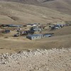
South Hebron Hills, north of the Green Line
Dkeika
Resident
Number of Families
46
Sub-Tribe
Furijat
Names of Families
Najada, Baraga, Guerab
Refugees
official refugee status
Refugees Details
90% are official refugees
Spatial/Building
Land Ownership
private
Planning
submitted plan
Planning - details
A plan for the village was submitted a few years ago but has been rejected. There is an on going petition in the supreme court.
Structure Type
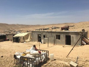
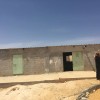
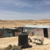
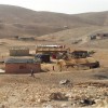
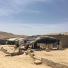
- tent
- tin shack
- stone
Infrastructure/Services
Access to Community
- pedestrian
- private vehicle
Access to Community - details
There is one access point to the community
Water Access
- water tank
- connection to neighboring village
- cistern\well
Water Access - details
Water comes only one day per week.
Electric Connection
Electric Connection - details
ARIJ (National NGO) provided them recently with a solar panels system but the panels cannot produce enough electricity for the families. Comet-ME are further developing the electricity network which is installed by ARIJ.
Health Care
- mobile clinic in community
- clinic in neighboring community
- clinic in distant town/village
Health Care - details
The community is out of reach for ambulances. In one case a family had to move in order to get ambulance services as a family member became ill. They have a mobile clinic next to the school, another health center in Hamida, and the nearest hospitals are in Jericho.
Location of Services
Yatta and Hebron
Education
Kindergarten
yes
Kindergarten - details
Attached to the school in Dkeika
Location of School #1
Dkeika
general description [school #1]
- Boys
- Girls
- Primary school
Distances to schools [school #1]
301 - 1000 meter
Location of School #2
Najada
Time to schools [school #1]
5 - 15 minutes
general description [school #2]
- Boys
- Girls
- Middle school
Time to schools [school #2]
31 minutes - 1 hour
Distances to schools [school #2]
more than 5001 meters
Location of School #3
Um al-Kher
general description [school #3]
- Boys
- Girls
- High School
Distances to schools [school #3]
more than 5001 meters
Time to schools [school #3]
31 minutes - 1 hour
Schools - details
There is an elementary school within the community. The high schools in Najada and Um-Al kher are about 6 Km away. Students in these schools are driven by a car organized by the community for this purpose.
Travel to school [school #1]
- easy walk
- difficult walk
Travel to school [school #2]
- difficult walk
- private car
Travel to school [school #3]
- difficult walk
- private car
Accessibility to school [school #1]
2
Accessibility to school [school #2]
6
Accessibility to school [school #3]
7
History
History
The community resides in its original territories which was divided in 1949 by the Green Line, and most of their lands were left behind the Green Line in Israeli territories. Some parts of the community were forced to move to other areas of the West Bank.
livelihood
Seasonal Movement
partly
Seasonal Movement - details
Some families move to Jabal Ashih in the western side of the community in the summer.
Community Initiatives
no Initiatives
Other Occupation
shepherding
Main Occupation
shepherding
Woman's Occupation
- taking care of the herd
- taking care of the kids
- housekeeping
- herd products
General Livelihood - details
Limited grazing area, to the north of the community.
The women produce some milk products.
The women produce some milk products.
Threats and obstacles
Threats and Obstacles
fjfxjsfjsyjsyj
- firing zone/closed military zone
- within settlement plan
- separation barrier
Threats and Obstacles - details
The planned route of the separation barrier, which is adjacent to the houses of the community, has not been built yet. There are two closed military zones to the east and west of the community.
The outline plan of Megillot regional council (which covers six settlements) is covering some part of the community territory.
The outline plan of Megillot regional council (which covers six settlements) is covering some part of the community territory.
Number of Demolition Orders
120
Number of Demolitions
15
Demolitions - date of update
September 17, 2010
Demolitions - details
According to the comunity, the ICA started demolitions in the area in 1998. In 2011, 15 houses were demolished, as well as part of the school.

