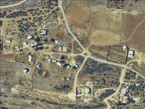
On village land of Deir Nitham
Deir Nitham - Al Hossa
Basic info+
Resident+
Number of Families
16
Tribe
testing the tooltip
Ka’abneh
Sub-Tribe
Furijat
Names of Families
Najadeh
Refugees
non-official refugee status
Spatial/Building+
Land Ownership
private
Land Ownership - details
The Bedouin bought lands from the owner in the village of Deir Nitham.
Planning
No plan
Structure Type
tent;EU shack;concrete;wood
Infrastructure/Services+
Access to Community
pedestrian;private vehicle
Access to Community - details
first access to the community was available through the village of Deir Nitham, the main entrance from the village was damaged and they were not allowed to restart the rehabilitation works. the other way to access is through the western entrance to Deir Nitham to the north of road 465. At this entrance, which is closer to the community, the army placed an iron gate that closes during any security decision or event that occurs.
Water Access
connection to neighboring village
Water Access - details
The community was connected to water by the ICA in 2012. Until 2000 they had a water filling point which is now located closer and there are connections to all the houses.
Electric Connection
Electric Connection - details
The community is connected to a house in Deir Nitham since 2013.
Health Care
clinic in neighboring community;clinic in distant town/village
Health Care - details
The nearest clinic is in Deir Nitham. The nearest hospitals are in Ramallah.
Location of Services
Ramallah, Deir Nitham
Education+
Kindergarten
No
Location of School #1
Deir Nitham
general description [school #1]
Boys;Girls;Primary school
Distances to schools [school #1]
1001 - 2000 meters
Location of School #2
Deir Nitham
Time to schools [school #1]
5 - 15 minutes
general description [school #2]
Boys;Girls;Middle school
Time to schools [school #2]
5 - 15 minutes
Distances to schools [school #2]
1001 - 2000 meters
Location of School #3
Deir Nitham
general description [school #3]
Boys;Girls;High School
Distances to schools [school #3]
1001 - 2000 meters
Time to schools [school #3]
5 - 15 minutes
Travel to school [school #1]
difficult walk;private car
Travel to school [school #2]
difficult walk;private car
Travel to school [school #3]
difficult walk;private car
Accessibility to school [school #1]
2
Accessibility to school [school #2]
2
Accessibility to school [school #3]
2
History+
History
The Najada family is originally from South Hebron hills (Masafer Yatta), they used to live on both sides of the green line before 1949. They were expelled from their land in the beginning of the 1950's.
livelihood+
Seasonal Movement
no
Community Initiatives
Unknown
Other Occupation
shepherding;herd without shepherding;temporary employment in Israel;daily laborer
Main Occupation
shepherding;herd without shepherding;temporary employment in Israel
Woman's Occupation
taking care of the herd;taking care of the kids;housekeeping;herd products
General Livelihood - details
The community owns about 200 sheep and goats. The IDF does not allow herding on the other side of Road 465, limiting their access to pasture land near Nabi Salih. Due to the decrease in grazing areas, some have become day laborers in Bir Zeit and Rawabi and workers in the field of building in Israel.
Threats and obstacles+
Threats and Obstacles
fjfxjsfjsyjsyj
nature reserve;close to settlement;road
Number of Demolition Orders
19
Number of Demolitions
2
Demolitions - details
In 2000 there were massive demolitions in the place and two days after the demolition they rebuilt all the destroyed houses. People sold many of the herds they claim it was to hire a private lawyer (Sliman Shaheen) to handle the demolition orders defense. (To date, they have paid the lawyer about 100,000 NIS from their own pockets)
In 2020 the ICA demolished two houses each measuring 65 square meters for two families and the houses were inhabited.
In 2020 the ICA demolished two houses each measuring 65 square meters for two families and the houses were inhabited.

