West of Ramallah
Deir Abu Masha'al
Resident
Number of Families
4
Names of Families
Abu Ia'beid
Farmers Origin/Family
Yatta
Refugees
not refugee
Spatial/Building
Land Ownership
private
Land Ownership - details
The villagers bought approximately 20 dunam of land from land owners of the town of Deir Abu Masha'al.
Planning
No plan
Structure Type
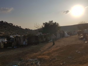
tent;tin shack
Infrastructure/Services
Access to Community
pedestrian;private vehicle;4X4 vehicle
Access to Community - details
The community is close to a main paved road.
Water Access
authorized connection
Water Access - details
They are connected to water system of the adjacent town of Deir Abu Mashal. They pay the town based on a water meter installed for their usage. The connection is faulty with many leaks and they pay for large losses of water which have accumulated into large debts.
Electric Connection
Electric Connection - details
The community purchased solar panels with the help of Bimkom and Comet Me. They have not proved to be effective or economically viable, and new panels or alternatives are being explored.
Health Care
clinic in neighboring community
Health Care - details
There is a clinic in the nearby village of 'Aboud.
Location of Services
Most of the services are in Aboud and the main hospital in Ramallah.
Education
Kindergarten
No
Location of School #1
A'boud
general description [school #1]
Boys;Girls;Primary school;Middle school;High School
Distances to schools [school #1]
2001 - 5000 meters
Time to schools [school #1]
16 - 30 minutes
Travel to school [school #1]
private car
Accessibility to school [school #1]
3
History
History
The community is originally from Yatta area (Attaban) and arrived in Deir Abu Masha'al in 2001 after several other locations.
After leaving Yatta they resided in the Nablus in the summer and al 'Auja mainly in the winter season. They were expelled from al 'Auja after the army destroyed their homes. They moved to Shuqba village lands for about a year before moving to Abud. They resided in the village of Abud for 6 years then moving to their current location.
After leaving Yatta they resided in the Nablus in the summer and al 'Auja mainly in the winter season. They were expelled from al 'Auja after the army destroyed their homes. They moved to Shuqba village lands for about a year before moving to Abud. They resided in the village of Abud for 6 years then moving to their current location.
livelihood
Seasonal Movement
no
Community Initiatives
public building;agriculture
Initiative in the community - details
The community is interested in building additional houses and digging water wells.
Other Occupation
shepherding;herd without shepherding;permanent employment in Palestinian town
Main Occupation
shepherding;herd without shepherding;permanent employment in Palestinian town
Woman's Occupation
taking care of the herd;housekeeping
General Livelihood - details
Higher education is increasing in the younger generation.
Threats and obstacles
Threats and Obstacles
fjfxjsfjsyjsyj
road
Threats and Obstacles - details
The bypass road that allowed them paved access to the village of Aboud (location of most of their services) has been closed with a guard rail, making the road inaccessible to vehicular traffic to and from the village. They have access to a dirt road to the village of Aboud but it makes access to the village more cumbersome. In addition, there are threats of demolition orders on the houses.
Number of Demolition Orders
11
Number of Demolitions
1


