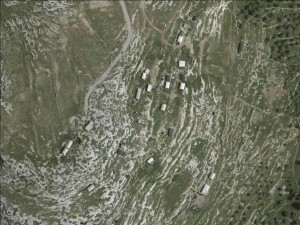
North of Bil'in
Arab al Jahalin - Ein Ayoub
Resident
Number of Families
14
Tribe
testing the tooltip
Jahalin
Sub-Tribe
Abu Dahouk
Names of Families
Kurshan
Refugees
non-official refugee status
Spatial/Building
Land Ownership
lease
Planning
No plan
Structure Type
- tent
- tin shack
- EU shack
Infrastructure/Services
Access to Community
- pedestrian
- private vehicle
Access to Community - details
The road leading to the area is unpaved and disturbed
Water Access
connection to neighboring village
Water Access - details
Water from Ras Karkar
Electric Connection
Health Care
- mobile clinic in community
- clinic in neighboring village
Health Care - details
Clinic in Ras Karkar and main hospital in Ramallah
Location of Services
Ramallah
Education
Kindergarten
No
Location of School #1
Deir A'mmar
general description [school #1]
- Boys
- Girls
- Primary school
Distances to schools [school #1]
1001 - 2000 meters
Location of School #2
Deir A'mmar
Time to schools [school #1]
16 - 30 minutes
general description [school #2]
- Boys
- Girls
- Middle school
Time to schools [school #2]
16 - 30 minutes
Distances to schools [school #2]
1001 - 2000 meters
Location of School #3
Deir A'mmar
general description [school #3]
- Boys
- Girls
- High School
Distances to schools [school #3]
1001 - 2000 meters
Time to schools [school #3]
16 - 30 minutes
Travel to school [school #1]
difficult walk
Travel to school [school #2]
difficult walk
Travel to school [school #3]
difficult walk
Accessibility to school [school #1]
5
Accessibility to school [school #2]
5
Accessibility to school [school #3]
5
History
History
Originally from Bir Esbea' (Be'er Sheva), they were expelled and became refugees in 1948. Most of them arrived to Za'atra near Bethlehem after 1948. In 1967 a statistic survey indicated some of them as residents of Za'atra. Those that were not calculated into the statistics left during the 80's. Another reason for leaving was the declaring of the area as a closed military zone. The location of Ein Ayoub was chosen due to its proximity to a water source and its grazing land.
livelihood
Seasonal Movement
no
Community Initiatives
no Initiatives
Other Occupation
- shepherding
- herd without shepherding
Main Occupation
- shepherding
- herd without shepherding
Woman's Occupation
- taking care of the herd
- taking care of the kids
- housekeeping
General Livelihood - details
Their grazing area was located west of the road leading to Ras Karkar. Today the access to it is denied.
Threats and obstacles
Threats and Obstacles
fjfxjsfjsyjsyj
road
Threats and Obstacles - details
Residents of Dir Amar village deny access to land. The community cannot reach any of its grazing areas.
Number of Demolition Orders
10
Number of Demolitions
10
Demolitions - date of update
September 17, 2010
Demolitions - details
According to the community, in the end of November 2011, cease-work orders were issued. In December 2013 the entire compound was demolished. The residents of Ain Ayoub managed to rebuild the tents and tin shacks. NGOs that arrived to the area ( brought more shacks yet their access to the area was denied by the inhabitants of Ras Karkar who were anxious about the Bedouin community settling on their lands. In 2015 new demolition orders were issued for new structures.


