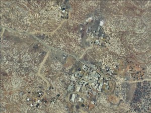
Central West Bank, South of Qalqiliya
Arab Abu Farda
Resident
Number of Families
35
Tribe
testing the tooltip
Abu Fardeh
Names of Families
Abu Farda
Farmers Origin/Family
From Al Basa area, near the city of Netanya today
Refugees
non-official refugee status
Spatial/Building
Land Ownership
private
Land Ownership - details
In 1957, the residents bought about 60 donums of land from the villages of Azzun and Sabah, according to residents of the Azzun area, who have taboo documents. The also bought lands from Hableh village.
Planning
community initiative plan
Planning - details
IPCC was hired by the PA to prepare the plan together with Arab Aramadin. The plan didn't receive any statutory phase.
Structure Type
- tent
- tin shack
- concrete
Infrastructure/Services
Access to Community
private vehicle
Water Access
connection to neighboring village
Electric Connection - details
The PA under the administration of Yaser Arafat funded a generator and electricity grid in 1996 but it no loner works. The families use personal solar panels and generators that work partially.
Health Care
clinic in distant town/village
Health Care - details
The UNRWA Clinic in Qalqilya city is the nearest health establishment
Location of Services
Qalqilya city
Education
Kindergarten
No
Location of School #1
Arab Aramadin Al Janoubi
general description [school #1]
- Boys
- Girls
- Primary school
Distances to schools [school #1]
0-300 meter
Location of School #2
Enabi Elias
Time to schools [school #1]
5 - 15 minutes
general description [school #2]
- Boys
- Girls
- Primary school
Time to schools [school #2]
16 - 30 minutes
Distances to schools [school #2]
2001 - 5000 meters
Location of School #3
Enabi Elias
general description [school #3]
- Boys
- Girls
- Middle school
Distances to schools [school #3]
2001 - 5000 meters
Location of School #4
Enabi Elias
Time to schools [school #3]
16 - 30 minutes
general description [school #4]
- Boys
- Girls
- High School
Distances to schools [school #4]
2001 - 5000 meters
Time to schools [school #4]
16 - 30 minutes
Schools - details
The staff comes by bus from Qalqilya through the Elyaho checkpoint
Travel to school [school #1]
difficult walk
Travel to school [school #2]
- bus
- private car
Travel to school [school #3]
- bus
- private car
Travel to school [school #4]
- bus
- private car
Accessibility to school [school #1]
4
Accessibility to school [school #2]
5
Accessibility to school [school #3]
5
Accessibility to school [school #4]
5
Accessibility to school - STAFF [school #1]
6
History
History
The community is from Al Bassa area, next to Netanya today. They lived near the Huwaitat clan of the Mawasa family (Mwisat), with whom they had a good relationship. They were expelled from there in 1948 and came to the Qalqiliya region where they are currently settled.
livelihood
Seasonal Movement
no
Community Initiatives
no Initiatives
Other Occupation
herd without shepherding
Main Occupation
herd without shepherding
Woman's Occupation
- taking care of the herd
- taking care of the kids
- housekeeping
General Livelihood - details
The community grows cows, chickens, and goats
Threats and obstacles
Threats and Obstacles
fjfxjsfjsyjsyj
- close to settlement
- separation barrier
- road
Threats and Obstacles - details
The separation barrier surrounds the community from all sides and creates an enclave where they are found today. The Elyaho checkpoint separates them from the surrounding Palestinian villages.
The settlement of Alfei Menasheh has a claims on some of their lands, and there are the demolition orders for any attempt to expand the building units.
They are also constantly watched and hassled by Regavim, a pro-settler NGO which monitors the construction actions of Palestinians.
The settlement of Alfei Menasheh has a claims on some of their lands, and there are the demolition orders for any attempt to expand the building units.
They are also constantly watched and hassled by Regavim, a pro-settler NGO which monitors the construction actions of Palestinians.
Number of Demolition Orders
17
Number of Demolitions
2
Demolitions - date of update
September 17, 2010


