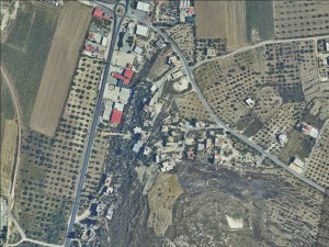
Northern West Bank, southwest of Jenin
Al-Hafira
Resident
Number of Families
20
Tribe
testing the tooltip
Sawarkeh
Names of Families
Dar Esokhon, El Qakoun, Salah El Mohor, Abu A'li
Farmers Origin/Family
Khdeira, Qaqoun, and Sinai
Refugees
official refugee status
Spatial/Building
Land Ownership
private
Land Ownership - details
The community bought most of the land they sit on from the 50's onward.
Planning
No plan
Structure Type
- tin shack
- concrete
Infrastructure/Services
Access to Community
- private vehicle
- public transit
Access to Community - details
Public transport does not reach the community.
Water Access
- water tank
- connection to neighboring village
Water Access - details
The community gets water from Mirkeh twice a week. During the rest of the time they use water tanks.
Electric Connection
Electric Connection - details
They community gets electricity from Mirkeh. The connections are bad and in need of maintenance. The community has asked for the power adapter to be fixed and the the columns and cables to be repaired, but have not received any response.
Health Care
clinic in neighboring community
Health Care - details
Clinics are in Mirkeh and A'rrabeh. The nearest hospital is in Jenin
Location of Services
A'rrabeh
Education
Kindergarten
No
Location of School #1
Mirkeh
general description [school #1]
- Boys
- Girls
- Primary school
Distances to schools [school #1]
1001 - 2000 meters
Location of School #2
A'rrabeh
Time to schools [school #1]
5 - 15 minutes
general description [school #2]
- Boys
- Girls
- Primary school
Time to schools [school #2]
16 - 30 minutes
Distances to schools [school #2]
2001 - 5000 meters
Location of School #3
A'rrabeh
general description [school #3]
- Boys
- Girls
- Primary school
Distances to schools [school #3]
2001 - 5000 meters
Time to schools [school #3]
16 - 30 minutes
Travel to school [school #1]
private car
Travel to school [school #2]
private car
Travel to school [school #3]
private car
Accessibility to school [school #1]
4
Accessibility to school [school #2]
4
Accessibility to school [school #3]
4
History
History
The farmers were displaced from the villages of Khdeira and Qaqoun inside the green line. The Bedouins in the community (As Sawarkeh) came from Sinai in 1948.
livelihood
Seasonal Movement
no
Community Initiatives
public building
Initiative in the community - details
The community built a Mosque. They also initiated the establishment of a joint village council for Adamayra and El Hafira, which is called the Al Hafira council.
Other Occupation
- shepherding
- herd without shepherding
- daily laborer
- employed by PA
- agriculture
Main Occupation
shepherding
Woman's Occupation
- taking care of the herd
- taking care of the kids
- housekeeping
- agriculture
Threats and obstacles
Threats and Obstacles
fjfxjsfjsyjsyj
- close to settlement
- road
- Mines
Threats and Obstacles - details
The grazing area used by the community next to Wadi Dauoq used to be a mine field, and is dangerous. International teams are trying to remove the mines and clear the area.
The checkpoint of Mevo Dotan settlement is close by and further restricts the movement of the community.
The checkpoint of Mevo Dotan settlement is close by and further restricts the movement of the community.
Number of Demolition Orders
12
Number of Demolitions
1
Demolitions - date of update
September 17, 2010
Demolitions - details
According to residents, they received a demolition order for a road they tried to pave between Al Hafira and Qabatya, in addition to a mosque they tried to build


