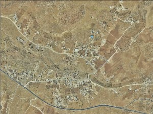
South Hebron Hills, adjacent to Road 356
Ad-Deirat
Resident
Number of Families
220
Names of Families
El A'dra, the sub families Hamamdeh, Mise'd, jabarin, Dar Mhamad
Farmers Origin/Family
Yatta
Refugees
not refugee
Spatial/Building
Land Ownership
private
Planning
- approved plan
- submitted plan
Planning - details
There is a special outline plan for the village but many structures were excluded from its boundaries. The village council initiated a new plan following new demolition orders in the area, yet the new plan didn't receive any statutory phase.
Structure Type
- tent
- tin shack
- concrete
- stone
Infrastructure/Services
Access to Community
- pedestrian
- private vehicle
Access to Community - details
No public transportation reaches the area. To get to Hebron they must hitch-hike on road 317 or arrange with someone they know that has a private car.
The roads within the community are unpaved and difficult to walk on.
The roads within the community are unpaved and difficult to walk on.
Water Access
- authorized connection
- water tank
Water Access - details
The community is connected to an authorized connection but the pipes are in severe need of maintenance and barely any water comes through, which forces the community to buy water in tanks. They buy the water tanks from A-Tuwani and Hebron.
Health Care
- permanent clinic in community
- mobile clinic in community
- clinic in distant town/village
Health Care - details
There is a maternity clinic in the village. For any other medical needs they are referred to Yatta.
Location of Services
Yatta and Hebron
Education
Kindergarten
yes
Kindergarten - details
They designated two rooms inside the elementary school building for a kindergarten
Location of School #1
Al Deirat
general description [school #1]
- Boys
- Girls
- Primary school
Distances to schools [school #1]
0-300 meter
Location of School #2
Khalet al May
Time to schools [school #1]
5 - 15 minutes
general description [school #2]
- Boys
- Girls
- Primary school
- Middle school
Time to schools [school #2]
31 minutes - 1 hour
Distances to schools [school #2]
2001 - 5000 meters
Travel to school [school #1]
easy walk
Travel to school [school #2]
difficult walk
Accessibility to school [school #1]
2
Accessibility to school [school #2]
6
Accessibility to school - STAFF [school #1]
4
Accessibility to school - STAFF [school #2]
4
History
History
The area was used by the community as a seasonal grazing area (Izbeh) originally but has become their permanent area of residence in the 60's.
livelihood
Seasonal Movement
yes
Seasonal Movement - details
Between spring and winter many people from the community move to east Masafer Yatta and Khirbet Zaa'tara. In the summer they return to the village.
Community Initiatives
- water
- elec'
Other Occupation
- shepherding
- temporary employment in Israel
- employed by PA
Main Occupation
shepherding
Woman's Occupation
- taking care of the herd
- taking care of the kids
- housekeeping
Threats and obstacles
Threats and Obstacles
fjfxjsfjsyjsyj
- close to settlement
- road
Threats and Obstacles - details
Road 356 is dangerous and many accidents occur there.
The surrounding settlements of Camel and Ma'on control their lands and severely restrict their grazing areas.
There is also a plan for a new regional road that will be built in the middle of the village.
The surrounding settlements of Camel and Ma'on control their lands and severely restrict their grazing areas.
There is also a plan for a new regional road that will be built in the middle of the village.
Number of Demolition Orders
149
Number of Demolitions
14
Demolitions - date of update
September 17, 2010


