Jerusalem periphery, north of A-Ram
Abu Shoushah Bedouins (Umm Suejah)
Resident
Number of Families
20
Tribe
testing the tooltip
Jahalin
Sub-Tribe
Kaabneh: Furijat, Najadeh, Imleihat. Jahalin: Saraya, Ara'ara
Names of Families
Bedouins: Najadeh, A'raa'ra, Te'imat, Imleihat (Izheiman), Fellahin: Wazwaz, Abu Ramouz
Farmers Origin/Family
Jerusalem
Refugees
- not refugee
- official refugee status
- non-official refugee status
Spatial/Building
Land Ownership
- private
- lease
Land Ownership - details
The lands belong to people from Jaba' and from A-Ram. Some plots were bought by the community from residents in Jerusalem and other locations.
Planning
No plan
Structure Type
- tent
- tin shack
- concrete
- stone
- wood
Infrastructure/Services
Access to Community
- private vehicle
- 4X4 vehicle
Access to Community - details
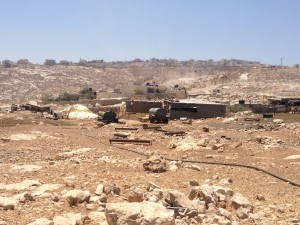
The dirt road that passes through the quarry is the only access to the community. It is dangerous, specially for kids who go to school, and is polluted. Heavy trucks pass through this road all the time.
They used to use the entrance in the east, connecting to road no' 60, but this was closed with a gate by the ICA, and they are forbidden from using it.
They used to use the entrance in the east, connecting to road no' 60, but this was closed with a gate by the ICA, and they are forbidden from using it.
Water Access
- authorized connection
- water tank
- connection to neighboring village
Water Access - details
Each compound in the community receives water from a different source. Some get water from the quarry, and some are connected to the houses that have an authorized connection. Some buy water tanks from A-ram.
Electric Connection - details
Each compound in the community receives electricity from a different source. Some are connected to private houses, others use generators, and those who take water from the quarry they take electricity from the same source.
Health Care
clinic in distant town/village
Health Care - details
Families with a refugee stats go to the UNRWA Hospital in Qalandya Camp. The others go to Ramallah for hospital or private clinics.
The hospital in Ramallah is the most used hospital of this community.
The hospital in Ramallah is the most used hospital of this community.
Location of Services
A-Ram, Jaba'
Education
Kindergarten
No
Location of School #1
A'raa'ra school
general description [school #1]
- Boys
- Girls
- Primary school
Distances to schools [school #1]
more than 5001 meters
Location of School #2
Jaba'
Time to schools [school #1]
16 - 30 minutes
general description [school #2]
- Boys
- Girls
- Middle school
- High School
Time to schools [school #2]
16 - 30 minutes
Distances to schools [school #2]
more than 5001 meters
Location of School #3
A-Ram
general description [school #3]
- Boys
- Girls
- Middle school
- High School
Distances to schools [school #3]
more than 5001 meters
Time to schools [school #3]
16 - 30 minutes
Travel to school [school #1]
- difficult walk
- donkey
- private car
Travel to school [school #2]
- difficult walk
- donkey
- private car
Travel to school [school #3]
- difficult walk
- donkey
- private car
Accessibility to school [school #1]
6
Accessibility to school [school #2]
6
Accessibility to school [school #3]
6
History
History
Each family came from different area. The A'raa'ra family were expelled from Tel Arad in 1948 and came to Masafer Yatta. They then moved to Khan al Ahmar.The Najadeh familly were expelled from the Negev in 1948 to Masafer Yatta and then arrived to Khan al Ahmar. In 1976 they were forcibly transferred from Maa'leh Adumim area to Jaba' and then to Abu Shousheh. The Imleihat were expelled in 1948 from Tel Arad to Hebron and then to the Jordan Valley, khan al Ahmar, and Beit Hanina (Tal A'daseh). In 2013 they moved to Abu Shousheh.
livelihood
Seasonal Movement
partly
Seasonal Movement - details
Some shepherds try to go to Baqa'a area in the winter, and others to Mua'arajat area. Since road 60 was paved this has become difficult.
Community Initiatives
Unknown
Other Occupation
- shepherding
- herd without shepherding
- permanent employment in Palestinian town
Main Occupation
- shepherding
- herd without shepherding
Woman's Occupation
- taking care of the herd
- taking care of the kids
- housekeeping
General Livelihood - details
The number of their herds was dramatically reduced due to lack of grazing lands in the surrounding areas, especially after they were forbidden from grazing close to the nearby settlements.
Threats and obstacles
Threats and Obstacles
fjfxjsfjsyjsyj
- firing zone/closed military zone
- nature reserve
- close to settlement
- settler violence
- road
- quarry
- Wastewater treatment facility
Threats and Obstacles - details
The community is blocked from all sides: Road 60 from east, Kokhav Yaa'kov settlement from North, Megron north east, the industrial area of Binyamin from north east, and the Abu Shousheh quarries from west.
They have no grazing areas, as it is forbidden to graze within less than 500 m distance from settlements, which is less than the distance between the community and the settlements surrounding it.
the expansion of road 60 blocks access to grazing lands on the other side of the road.
They have no grazing areas, as it is forbidden to graze within less than 500 m distance from settlements, which is less than the distance between the community and the settlements surrounding it.
the expansion of road 60 blocks access to grazing lands on the other side of the road.
Number of Demolition Orders
13
Number of Demolitions
0
Demolitions - date of update
September 17, 2010


