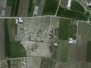
Northern West Bank, southwest of Jenin
Ad-Damayra
Basic info+
Resident+
Refugees
official refugee status
Refugees Details
Refugees from 1948 from the village of Ad-Damayra, after which their current village is named.
Spatial/Building+
Land Ownership
private
Land Ownership - details
The community purchased land in the 1960s
Planning
No plan
Infrastructure/Services+
Access to Community
- pedestrian
- private vehicle
- 4X4 vehicle
Water Access
connection to neighboring village
Water Access - details
Connected to the village of Marqa.
Electric Connection
Electric Connection - details
Connected to the village of Marqa.
Health Care
clinic in neighboring community
Health Care - details
The community uses clinics in Marqa and Araba as needed.
Location of Services
Araba and Marqa
Education+
Kindergarten
Unknown
Location of School #1
Araba
Distances to schools [school #1]
2001 - 5000 meters
Location of School #2
Marqa
Distances to schools [school #2]
2001 - 5000 meters
Schools - details
The children either walk to school or get rides in private cars.
Travel to school [school #1]
- difficult walk
- private car
Travel to school [school #2]
- difficult walk
- private car
History+
History
The community rented land until the 1960s, but they have since bought land.
livelihood+
Seasonal Movement
no
Other Occupation
temporary employment in Israel
Main Occupation
temporary employment in Israel
Woman's Occupation
- taking care of the kids
- housekeeping
Threats and obstacles+
Threats and Obstacles
fjfxjsfjsyjsyj
- nature reserve
- archeology
Threats and Obstacles - details
Adjacent to Tel Dotan
Number of Demolition Orders
2
Number of Demolitions
0

