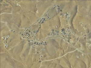
South Hebron Hills, along Road 3269
An Najada
Resident
Number of Families
88
Sub-Tribe
Furijat
Names of Families
Najadeh and Mleihat
Refugees
non-official refugee status
Spatial/Building
Land Ownership
- private
- Unknown
Planning
Demarcation plan
Structure Type
- tin shack
- concrete
- stone
Infrastructure/Services
Access to Community
- private vehicle
- public transit
Water Access
authorized connection
Water Access - details
The water supply is managed by the local council. A few villages share the use of water and each community is assigned specific days and times for filling/distribution of water. The water pipes are narrow and in need of maintenance which makes the water supply insufficient.
The community also has a cistern.
The community also has a cistern.
Electric Connection
Electric Connection - details
The community is connected to the electricity network
Health Care
- permanent clinic in community
- mobile clinic in community
- clinic in distant town/village
Health Care - details
The nearest hospital is the governmental hospital in Hebron
Location of Services
Hebron, Masafer Yatta
Education
Kindergarten
yes
Location of School #1
An Najada
general description [school #1]
- Boys
- Girls
- Primary school
- Middle school
Distances to schools [school #1]
0-300 meter
Location of School #2
Saraya'a School
Time to schools [school #1]
5 - 15 minutes
general description [school #2]
- Boys
- Girls
- High School
Time to schools [school #2]
16 - 30 minutes
Distances to schools [school #2]
2001 - 5000 meters
Travel to school [school #1]
- bus
- easy walk
- difficult walk
- donkey
Travel to school [school #2]
- difficult walk
- donkey
- private car
Accessibility to school [school #1]
1
Accessibility to school [school #2]
5
Accessibility to school - STAFF [school #1]
2
Accessibility to school - STAFF [school #2]
2
History
History
The community settled in the area before 1948. After the green line was set in 1949, following the 1948 war, the areas and the lands of the tribe (Adira area) were reduced, as parts of it were now under Israeli control. Those from the community who were in the Israeli parts were expelled in the early 1950s. Until 1967 the community used to nomad from the Israeli side to the Palestinian side. After the occupation of the west bank, they were forced to stay in the Palestinian parts of their lands.
livelihood
Seasonal Movement
partly
Seasonal Movement - details
Some families move in the winter to Dkeikeh
Initiative in the community - details
Establishing a natural reserve, that was demolished by the ICA in 2019.
Other Occupation
- shepherding
- temporary employment in Israel
- daily laborer
- employed by PA
- unemployed
Main Occupation
- shepherding
- daily laborer
Woman's Occupation
- taking care of the herd
- taking care of the kids
- housekeeping
- teachers/kindergarten teachers
- unemployed
Threats and obstacles
Threats and Obstacles
fjfxjsfjsyjsyj
firing zone/closed military zone
Threats and Obstacles - details
House demolition is the community's biggest threat
Number of Demolition Orders
10
Number of Demolitions
0
Demolitions - date of update
September 17, 2010


